

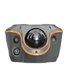
Deskripsi
Confidentand Consistent Accuracy in Obstruction. Once Right, Always Right.
SFix 2.0: Reliable 5 cm Accuracy within 20 m in GNSS-Denied Areas.
Real-Time 3D Point Cloud Earthwork Calculation: Accurate, Fast & Safe.
Vi-LiDAR: Take a Photo, Capture Points to Survey, No Need to Aim or Stay Rock-Steady.
All-in-One FlagshipGNSSReceiverwith All Conventional Features Involved.
Vi-LiDAR CONTACTLESS SURVEY
Batch Point Capture, Say Goodbye to Hand Tremors Vi-LiDAR capturesone photo and extract multiple 3D
coordinates instantly, no need to aim, stay steady, or align the range pole. Eliminating hand tremors, fewer human errors, providing faster, more reliable results from a safe distance.
Application Scenario
GNSS Signal
Obstructed Areas
GNSS Signal
Denied Areas
Earthwork Calculation
Contactless Surveying
Vi-LiDAR CONTACTLESS SURVEY
Batch Point Capture, Say Goodbye to Hand Tremors Vi-LiDAR capturesone photo and extract multiple 3D
coordinates instantly, no need to aim, stay steady, or align the range pole. Eliminating hand tremors, fewer human errors, providing faster, more reliable results from a safe distance.
Vi-LiDAR Camera
| Pixel | 8MP HD telephoto |
| Aperture | F/2.2 |
| FOV | 77.5°(H)* 48.8°(V) |
| Optimal Imaging Range | 5 – 20 m |
| Feature | Vi-LiDAR contactless survey, |
| AR visual navigation |


Ulasan
Belum ada ulasan.